DarkSky Sites
Winchester Gun Club
Located off of West
Camino Cielo, it can only be directly used by Gun Club Members
see
https://www.wcgc.org/. However, you may be able to find a place to park, off the road,
somewhere along West Camino Cielo, to setup your telescope.
East/West Camino Cielo is best when the city lights are blocked
by a low fog bank. These camera views, Santa Barbara
County Fire Webcams might help:
http://www.rntl.net/santa-barbara-county-fire-webcams/
However, you may be able to find a place to park, off the road,
somewhere along West Camino Cielo, to setup your telescope.
East/West Camino Cielo is best when the city lights are blocked
by a low fog bank. These camera views, Santa Barbara
County Fire Webcams might help:
http://www.rntl.net/santa-barbara-county-fire-webcams/
The Gun Club is located at an elevation
of roughly 3000 feet. It is removed enough from Santa
Barbara that much of the sky glow is eliminated.
To get to the Gun Club, take Highway
154 north over San Marcos Pass. Get off at West Camino Cielo.
The exit is a left-hand turn, almost at the top of the Pass.
Proceed about five miles until the pavement runs out. The road
is very twisty and often only one lane wide, so this 4.2 mile
distance takes about 15 minutes or so.
Figueroa Mountain
This is the best Dark sky you can get
to around here in an less than 1 1/2 Hour drive from Santa
Barbara and from Goleta its about 1 1/4 hour to get to the
site. There are 4 site's you can go to. Here I will give
directions to the 2 sites that I think are best.
Directions to Figueroa:
1. Take the 101 North. Exit at the 154 turn-off to Los Olivos.
It’s about 8 miles past Buellton.
1a. From Santa Barbara. take San Marcos Pass (154) to Los
Olivos. Turn Right on Figueroa Mountain Road.
1a. SKIP TO Step #3
2. Go east on the 154 towards Los Olivos and turn Left (north)
at Figueroa Mountain Road.
3. Stay on Figueroa Mountain Road at 11.8 miles you will come to
the Ranger Station.
Continue past the Figueroa Ranger Station. You will see the
station down to your right.
5. At about .7miles further you will see a dirt road on
the left with a metal road gate. This goes to Catway. Continue
on the paved road.
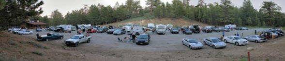
6. Site # 1 The Lookout
Take the next dirt road to your left 1.1miles past the Ranger
Station. If you stay on the pavement and you come to Figueroa
Mt. Campground, you've gone 1/4 to 1/3 of a mile to far. Double
back.
7. Follow the dirt road for about two miles. At the Pino Alto
turnoff take the right fork. Take the next fork to the right as
well. If you find yourself going downhill you are on the wrong
road. Follow the signs to the fire lookout. This is the spot.
8. SITE #2 The Saddle do not
take the dirt road on step #6 Continue on the paved road past
Figueroa Mt. Campground It will take you about another 6 to 10
min's to get to the RED MOUND on the right. 9. At about 4 Miles
you will come up on a Big Area of Red Dirt (RED MOUND) on your
right side. Your almost there. Some times you might see some of
the Vandenberg members at this spot.
10.Drive 0.7 miles past the next open gate. The road is kind of
narrow in spots and winds through a lot trees, then starts down
a little hill. You will see a small turnout on the left that is
where we set up.
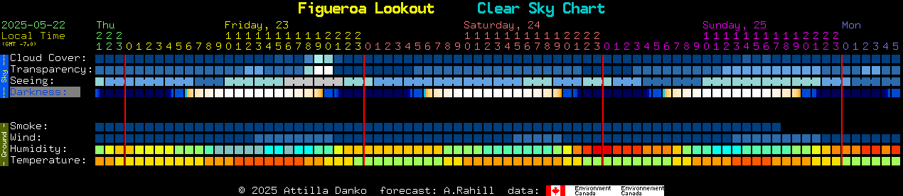
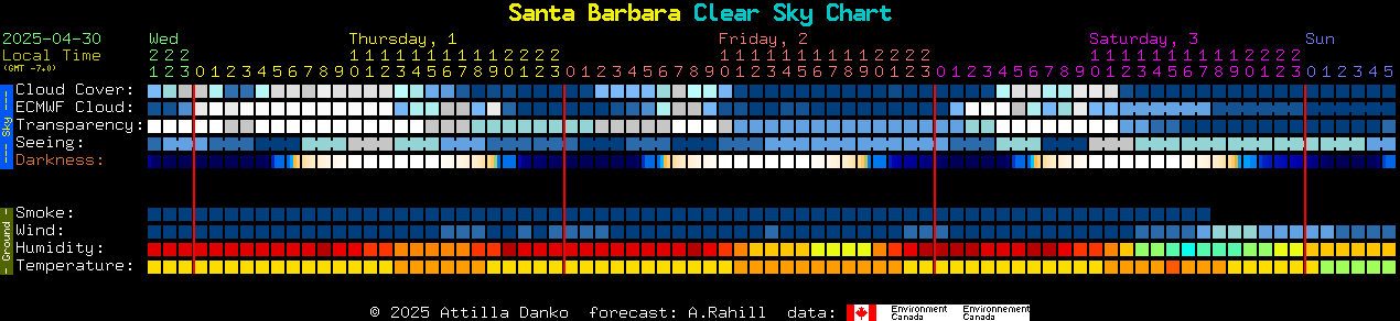
NOAA Forecast for Figueroa Mountain
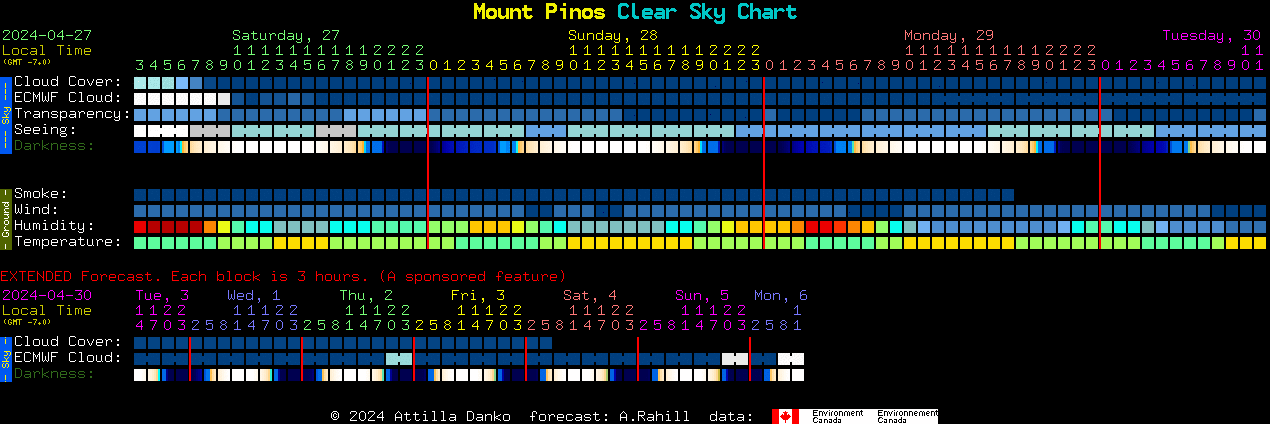
Mount Pinos
Mount Pinos is one of the darkest spots
you can get to with-in a 2 hr drive from Santa Barbara. During
the summer months and in to late fall you will find quite a
large crowd with lots of telescopes. Also I have taking a lot of
images from this site, but it is starting to show a lot of sky
glow compared to 20 years ago when I first started going to Mt
Pinos
Driving
Directions for the Santa Barbara Area.
Take US-101 South 29 miles to CA-126 E/State Route
126 (signs for Santa Clarita)
Drive 44 Miles to I-5 N take the ramp to Sacramento.
Drive 33 miles to exit 205 for Frazier Mountain Park Rd.
Turn left under the freeway and Continue up Cuddy Valley Rd
for 14.6 Miles.
Cuddy Valley Rd turns slightly left and becomes Mt
Pinos Rd.
Continue for about 9 Miles to the Mt Pinos Parking lot.
NOAA Forecast for Mount Pinos
Cachuma Lake
We use the Lake for both Outreach
events during the Summer and for our Astronomy Clubs Annual
AU Campout at the end of summer. Our Outreach events are at
the Dakota Plains area and out campouts are at Mohawk
Shores. I have done some Imaging here but there is a lot of
Sky Glow from Santa Barbara. If you happen to get a think
Fog bank over Santa Barbara then its a great place to image.
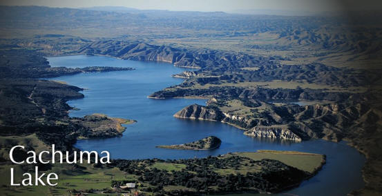
NOAA Forecast for Lake Cachuma

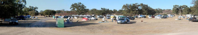
Lake San Antonio
Also
the site for Calstar
The overflow area at the lake is a
great place for observing. it gets very dark with a
fantastic horizon. I have taken some fantastic images here
and meet some very nice Astronomers at Calstar. The Overflow
area is the best place to setup. The Sky's here can be very
dark. It is camping is $37/night, but there's a
seniors discount, and I think this year if you camp 4
nights, one is free. You
also need to make sure that you bring lots of water. During
the Summer Months it can get over 100 Degrees here.
More info about Calstar 2018 and the lake can be found at
the following links.
http://calstar.observers.org/
http://lakesanantonioresort.com/
Driving Directions from Santa Barbara area.
Take US 101 North towards Paso Robles to the CA-46 W. About
118 miles
The turn Left under the Freeway on to 24th St. Continue for
about 1 mile.
Slight Right on to
Nacimiento Lake Dr/Paso Robles Rd
Drive for 7.5 miles
Turn right onto Godfrey Rd/ Naciminteo Lake Dr. Drive for
9.3 Miles
Turn Left onto Interlake Rd. Drive for 7.7 Miles
Turn right onto San Antonio Rd. Drive for 3.0 Miles. On this
road you will come up on the Lake Entrance.
This is where you will pay your park fee.
Continue straight onto Lynch Rd and drive about 1 Mile
Turn Right on to a Dirt Road. This is the Area you want to
be.
NOAA Forecast for Lake San Antonio

|